 English
 Română
A finished road can look simple once traffic starts moving. The difficult work happened much earlier.
Before construction could begin, someone had to decide where the road should run, how it would connect to the existing network and what would happen to rainwater during a heavy storm. The design also had to fit the available land, avoid or relocate utilities, respond to the ground conditions and meet the requirements of the authorities involved.
That is where the real complexity of road design lies. It is not just a matter of drawing an alignment. It means bringing many connected decisions into one solution that is safe, practical to approve and realistic to build.
This guide looks at how those decisions come together. It is written for public authorities, developers, contractors and project owners preparing a road or access-infrastructure project in Romania.
More than a line on a plan
A road has to do more than move vehicles from one point to another. It has to suit the people who will use it, fit the surrounding land and continue to perform after years of traffic and bad weather.
That sounds obvious, but it changes almost every design decision. A local access road does not need the same solution as an expressway. An industrial road may have to accommodate frequent heavy vehicles and unusual turning movements. A street in a built-up area must deal with pedestrians, property entrances, utilities and limited space.
The carriageway is only one part of the picture. Depending on the project, the design may also cover junctions, footways, cycling facilities, parking, earthworks, drainage, culverts, retaining structures, safety barriers, signs, road markings and lighting. The scope needs to be clear from the start. Otherwise, important tasks can sit between disciplines with nobody clearly responsible for them.
E-SFlows provides professional road design services for highways, national and local roads, industrial sites, junctions, parking areas and complex traffic layouts.
Why reliable information comes first
It is tempting to begin drawing as soon as a project starts. Sometimes that creates the appearance of progress, but a detailed drawing is only as reliable as the information beneath it.
Consider a utility shown in the wrong place. If it is discovered after the road levels have been fixed, several drawings may need to change. The same applies to an inaccurate property boundary, weak ground or a drainage outlet that cannot actually be used. Each issue may look small on its own, yet each can affect the alignment, cost and approval programme.
The information needed varies from one project to another. It often includes:
- topographic and cadastral surveys;
- geotechnical investigations;
- traffic counts and forecasts;
- utility records and field checks;
- hydrological and drainage information;
- environmental and property constraints;
- requirements issued by road administrators and other authorities.
Not every survey must be complete on the first day. What matters is knowing what is available, what still needs to be checked and which decisions depend on the missing information. A good project plan makes those dependencies visible instead of hiding them inside assumptions.
The decisions that shape the road
Geometry should make sense to the driver
Road geometry brings together the horizontal alignment, gradients, crossfall and sight distance. These elements are closely connected. Change one of them and the others may need to be reconsidered.
The road also has to communicate clearly with the person using it. Drivers need enough time to understand a curve, junction or lane change. Pedestrians and cyclists need routes and crossing points that do not place them in unexpected conflict with traffic. Meeting a numerical requirement is important, but it does not automatically make a layout easy to read.
Traffic data needs a purpose
A traffic count is useful only if it helps answer the question facing the project. Daily totals may not explain a junction that fails during one busy hour. A standard vehicle mix may not represent an industrial site used by articulated lorries. Future development can also change how an apparently adequate road performs.
The analysis should therefore reflect the decision being made. It may influence the number of lanes, the form of a junction, turning facilities, access arrangements or the space reserved for later expansion. Signs and markings then support the layout. They should not be used to compensate for confusing geometry.
Water cannot be treated as an afterthought
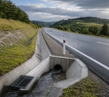
Roads change the way water moves across a site. Rain falls on an impermeable surface, reaches low points quickly and has to be collected and discharged safely. If that process is not understood, the result may be standing water, erosion, damaged earthworks or a shortened pavement life.
Good drainage starts with the road profile and the surrounding catchment. Ditches, channels, inlets, pipes, culverts and outlets then have to work together. Moving water away from the carriageway is not enough if the discharge creates a new problem farther downstream.
Ground conditions affect what can actually be built
The land beneath the road influences the pavement, slopes, foundations and construction method. Poor ground may need improvement or replacement. A deep cutting may introduce stability problems. A large embankment may settle over time.
These issues affect more than the engineering calculations. They influence quantities, land requirements, programme and cost. A route that looks shorter on a plan is not always the most efficient once its earthworks and structures are understood.
Structures and utilities need early coordination
Road and structural design meet at bridge approaches, clearances, foundations, drainage and construction sequencing. If a route includes an overpass, bridge or substantial culvert, involving the bridge design team early gives both disciplines a common basis for their work.
Utilities deserve the same attention. Existing records are useful, but they do not always prove the exact position or depth of a service. Early investigation makes it easier to decide whether the road can avoid the conflict or whether a diversion must become part of the project.
Safety has to be considered throughout the project
Road safety is not a final note added before a drawing is issued. It begins when options are compared and continues through design, construction and operation.
The European framework for road-infrastructure safety management includes impact assessments, audits, inspections and network-wide assessments for roads within its scope. It also requires the needs of vulnerable road users to be considered systematically. The official text of Directive 2008/96/EC is available on EUR-Lex.
The exact procedures depend on the road category, location, funding and approval route. They should be confirmed for the particular project rather than copied automatically from another scheme.
A useful review asks two separate questions: Is the design technically correct, and will it be clear and workable for the people who build, operate and use it?
Taking the design from the office to the construction site
A coordinated design should tell one consistent story. The drawings, calculations, specifications and quantities all need to describe the same solution. A level shown differently in two documents can become a delay, a technical query or an unnecessary variation on site.
Even a carefully prepared design will face questions during construction. The ground may differ from the investigation. A buried service may be found in an unexpected location. The contractor may propose a different sequence. What matters is that changes are reviewed, recorded and checked against the original design requirements.
This is where document control and clear communication become as important as the drawings themselves. Professional construction site supervision adds another level of control through inspections, documentation checks and monitoring of the approved technical requirements.
Where road projects often lose time
Delays do not always begin with a major engineering problem. More often, several smaller uncertainties are allowed to remain unresolved:
- the brief does not define who is responsible for each deliverable or approval;
- survey information is old, incomplete or accepted without checking;
- road, drainage, structure and utility designs develop separately for too long;
- authority requirements are identified after the programme has already been fixed;
- construction access and staging are left for the contractor to solve later;
- a lower initial cost is accepted without considering durability, maintenance or safety.
None of these situations is unusual. The difference is whether they are found while the design can still respond or after work has started on site.
What to prepare before requesting a proposal
You do not need to have every answer before speaking to a road designer. A useful initial enquiry should explain where the project is, what the road is expected to do, its approximate scale and the current stage of development.
It also helps to share any surveys, site boundaries, known utility information, expected programme and previous correspondence with authorities. If something important is missing, say so. The designer can then identify the investigations and early decisions that should form part of the proposal.
Questions clients often ask
When should a road designer become involved?
Ideally, while the brief and main options can still be influenced. Early engineering input helps identify survey needs, approval risks and structural interfaces before the project commits to one route or layout.
What information is needed to begin?
That depends on the design stage. The project location, intended road function, site boundaries, available surveys, traffic context, known utilities and approval route provide a useful starting point. The design team can identify the remaining gaps.
Can the same team coordinate roads and bridges?
Yes. Joint coordination is particularly valuable at bridge approaches, overpasses, culverts and retaining structures, where geometry, clearances, drainage and construction sequence affect both disciplines.
Can E-SFlows remain involved during construction?
Yes. E-SFlows also provides construction site supervision and technical monitoring. The exact role and deliverables are agreed for each project.